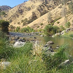
| Cache Creek Rivière la Cache | |
|---|---|
 Cache Creek, Upper Yolo County section, California | |
 | |
| Location | |
| Country | United States |
| State | California |
| Region | Yolo County, Colusa County, Lake County |
| Physical characteristics | |
| Source | Clear Lake |
| • location | southwest of Clearlake, California |
| • coordinates | 38°56′10″N 122°38′35″W / 38.93611°N 122.64306°W[1] |
| Mouth | Cache Creek Settling Basin |
• location | east of Woodland, California |
• coordinates | 38°41′24″N 121°41′30″W / 38.69000°N 121.69167°W[2] |
• elevation | 30 ft (9.1 m)[2] |
| Length | 87 mi (140 km) |
| Basin size | 1,139 sq mi (2,950 km2) |
| Discharge | |
| • location | Yolo, CA |
| • average | 533 cu ft/s (15.1 m3/s) |
| • minimum | 0 cu ft/s (0 m3/s) |
| • maximum | 41,400 cu ft/s (1,170 m3/s) |
| Basin features | |
| Tributaries | |
| • left | North Fork Cache Creek, Bear Creek |
Cache Creek is an 87-mile-long (140 km)[3] stream in Lake, Colusa and Yolo counties, California.
- ^ U.S. Geological Survey Geographic Names Information System: Cache Creek
- ^ a b U.S. Geological Survey Geographic Names Information System: Cache Creek Settling Basin
- ^ U.S. Geological Survey. National Hydrography Dataset high-resolution flowline data. The National Map Archived 2012-03-29 at the Wayback Machine, accessed March 10, 2011