| Cache la Poudre River | |
|---|---|
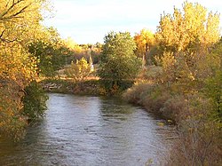
 Cache La Poudre River as it flows through Fort Collins, Colorado. | |
 | |
| Location | |
| Country | United States |
| State | Colorado |
| Cities | Fort Collins, Greeley |
| Physical characteristics | |
| Source | Rocky Mountains |
| • location | Rocky Mountain National Park |
| • coordinates | 40°25′29″N 105°48′24″W / 40.42472°N 105.80667°W[3] |
| • elevation | 10,755 ft (3,278 m)[4] |
| Mouth | South Platte River |
• location | Near Greeley |
• coordinates | 40°25′17″N 104°36′3″W / 40.42139°N 104.60083°W[3] |
• elevation | 4,600 ft (1,400 m)[4] |
| Length | 126 mi (203 km)[1] |
| Discharge | |
| • location | Fort Collins[2] |
| • average | 162 cu ft/s (4.6 m3/s)[2] |
| • minimum | 0 cu ft/s (0 m3/s) |
| • maximum | 6,080 cu ft/s (172 m3/s) |
| Basin features | |
| Tributaries | |
| • left | North Fork Cache la Poudre River |
| • right | South Fork Cache la Poudre River |
| Type | Wild, Recreational |
| Designated | October 30, 1986 |


The Cache la Poudre River (/ˌkæʃ lə ˈpuːdər/ KASH lə POO-dər), also known as the Poudre River, is a river in the state of Colorado in the United States.
- ^ Cache la Poudre River Archived 2008-08-30 at the Wayback Machine, The Columbia Gazetteer of North America. 2000.
- ^ a b Water Data Report, Colorado 2003, from Water Resources Data Colorado Water Year 2003, USGS.
- ^ a b U.S. Geological Survey Geographic Names Information System: Cache la Poudre River, USGS GNIS.
- ^ a b Google Earth elevation for GNIS coordinates.