Cachipay | |
|---|---|
Municipality and town | |
 Rainbow at the view of Cachipay | |
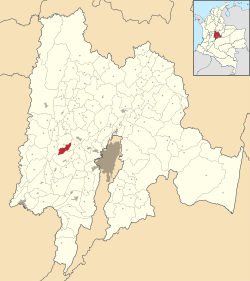
 Location of the municipality and town inside Cundinamarca Department of Colombia | |
| Coordinates: 4°43′51″N 74°26′15″W / 4.73083°N 74.43750°W | |
| Country | |
| Department | |
| Province | Tequendama Province |
| Founded | 26 November 1982 |
| Government | |
| • Mayor | Efraín Moncada Sánchez (2020-2023) |
| Area | |
• Municipality and town | 56 km2 (22 sq mi) |
| Elevation | 1,600 m (5,200 ft) |
| Population (2015) | |
• Municipality and town | 9,833 |
| • Density | 180/km2 (450/sq mi) |
| • Urban | 3,153 |
| Time zone | UTC-5 (Colombia Standard Time) |
| Website | Official website |
Cachipay is a municipality and town of Colombia in the Tequendama Province, part of the department of Cundinamarca. Cachipay borders Quipile in the west, Zipacón in the east, Anolaima in the north and La Mesa in the south. The urban centre is located 53 kilometres (33 mi) east of Bogotá.[1]
- ^ (in Spanish) Official website Cachipay[permanent dead link]


