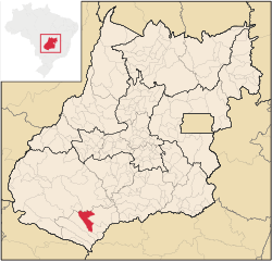
Cachoeira Alta | |
|---|---|
 Location in Goiás state | |
| Coordinates: 18°45′21″S 50°55′56″W / 18.75583°S 50.93222°W | |
| Country | Brazil |
| Region | Central-West |
| State | Goiás |
| Microregion | Quirinópolis Microregion |
| Area | |
| • Total | 1,654.3 km2 (638.7 sq mi) |
| Elevation | 483 m (1,585 ft) |
| Population (2020 [1]) | |
| • Total | 12,666 |
| • Density | 7.7/km2 (20/sq mi) |
| Time zone | UTC−3 (BRT) |
| Postal code | 75870-000 |
| Website | https://cachoeiraalta.go.gov.br/ |
Cachoeira Alta is a municipality in south Goiás state, Brazil. The population was 12,666 inhabitants in 2020 in a total area of 1659.4 km2. Cachoeira Alta has one of the largest cattle herds in the state.

