| Cagayan River Río Grande de Cagayán | |
|---|---|
 | |
 | |
Cagayan River mouth | |
| Native name | Bannag (Ibanag) |
| Location | |
| Country | |
| Region | Cagayan Valley |
| Province | |
| Physical characteristics | |
| Source | Caraballo Mountains |
| • location | Dupax del Sur, Nueva Vizcaya |
| • coordinates | 16°11′08″N 121°08′39″E / 16.18556°N 121.14417°E |
| • elevation | 1,524 m (5,000 ft) |
| Mouth | Babuyan Channel |
• location | Aparri, Cagayan |
• coordinates | 18°22′N 121°37′E / 18.367°N 121.617°E |
• elevation | 0 m (0 ft) |
| Length | 505 km (314 mi)[1] |
| Basin size | 27,753 km2 (10,715 sq mi)[2] |
| Basin features | |
| Tributaries | |
| • left | |
| • right | |
 | |
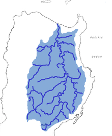
The Cagayan River, also known as the Río Grande de Cagayán, is the longest river[3][1] and the largest river by discharge volume of water in the Philippines. It has a total length of approximately 505 kilometres (314 mi) and a drainage basin covering 27,753 square kilometres (10,715 sq mi).[2] It is located in the Cagayan Valley region in northeastern part of Luzon Island and traverses the provinces of Nueva Vizcaya, Quirino, Isabela and Cagayan.
- ^ a b Kenneth Kimutai too (July 24, 2018). "Longest Rivers In The Philippines". worldatlas.com. WorldAtlas. Retrieved September 9, 2019.
- ^ a b Vicente B. Tuddao Jr. (September 21, 2011). "Water Quality Management in the Context of Basin Management: Water Quality, River Basin Management and Governance Dynamics in the Philippines" (PDF). www.wepa-db.net. Department of Environment and Natural Resources. Retrieved April 5, 2017.
- ^ "Taming the Cagayan River, Inquirer.net". Retrieved May 20, 2017.

