| Cagayan River | |
|---|---|
 Whitewater rafting along the Cagayan de Oro River | |
 | |
Cagayan de Oro River mouth | |
| Location | |
| Country | Philippines |
| Region | Northern Mindanao |
| Province | |
| City/municipality | |
| Physical characteristics | |
| Source | Kitanglad Mountain Range |
| • location | Kalatungan Mountain Range, Bukidnon, Northern Mindanao, Philippines |
| • coordinates | 7°57′27″N 124°48′57″E / 7.95750°N 124.81583°E |
| • elevation | 2,286 m (7,500 ft) |
| Mouth | Macajalar Bay |
• location | Cagayan de Oro, Northern Mindanao, Philippines |
• coordinates | 8°30′18″N 124°39′27″E / 8.50502°N 124.65753°E |
• elevation | 0 m (0 ft) |
| Length | 90 km (56 mi) |
| Basin size | 1,521 km2 (587 sq mi) |
| Discharge | |
| • location | Macajalar Bay |
| Basin features | |
| Tributaries | |
| • right | |
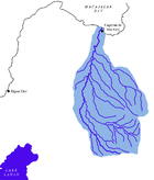
The Cagayan River, also known as the Cagayan de Oro River, is one of the rivers draining the northern central part of the island of Mindanao in the Philippines. The river has its headwaters in the Kalatungan Mountain Range and Kitanglad Mountain Range found in the central part of the province of Bukidnon. It traverses the municipalities of Talakag, Baungon, and Libona, connecting tributaries along the way. It finally empties into Macajalar Bay in Cagayan de Oro.
The river serves as the natural boundary between the province of Bukidnon and Iligan and between Bukidnon and Cagayan de Oro, based on the administrative order issued by the defunct Department of Mindanao and Sulu during the American occupation of the Philippines. In Cagayan de Oro, it is the dividing line between its two Congressional districts.
The Cagayan River is a very popular site for whitewater rafting in the Philippines and has been promoted by the Department of Tourism as the main tourist attraction of Cagayan de Oro.

