Calcutta, Ohio | |
|---|---|
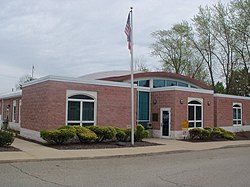
 St. Clair Township Government Building | |
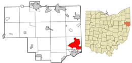
 Location of Calcutta in Columbiana County and in the State of Ohio | |
| Coordinates: 40°41′02″N 80°33′43″W / 40.68389°N 80.56194°W | |
| Country | United States |
| State | Ohio |
| County | Columbiana |
| Township | St. Clair |
| Established | 1810 |
| Named for | Calcutta, India |
| Area | |
• Total | 12.18 sq mi (31.56 km2) |
| • Land | 12.17 sq mi (31.52 km2) |
| • Water | 0.01 sq mi (0.03 km2) |
| Elevation | 1,129 ft (344 m) |
| Population (2020) | |
• Total | 3,941 |
| • Density | 323.80/sq mi (125.02/km2) |
| Time zone | UTC-5 (Eastern (EST)) |
| • Summer (DST) | UTC-4 (EDT) |
| ZIP code | 43920 |
| Area code(s) | 330, 234 |
| FIPS code | 39-10926[3] |
| GNIS feature ID | 2393360[2] |
| School District | Beaver Local School District |
Calcutta is an unincorporated community and census-designated place in southeastern St. Clair Township, Columbiana County, Ohio, United States. The population was 3,941 at the 2020 census.[4] Historically a rural town, Calcutta developed in the late 20th century as businesses from neighboring East Liverpool moved into larger shopping centers clustered around Ohio State Route 170.
- ^ "ArcGIS REST Services Directory". United States Census Bureau. Retrieved September 20, 2022.
- ^ a b U.S. Geological Survey Geographic Names Information System: Calcutta, Ohio
- ^ "U.S. Census website". United States Census Bureau. Retrieved January 31, 2008.
- ^ "Calcutta CDP, Ohio". U.S. Census Bureau. Retrieved March 24, 2022.