Caledon | |
|---|---|
| Town of Caledon | |
 | |
| Coordinates: 43°51′58″N 79°51′32″W / 43.86611°N 79.85889°W[1] | |
| Country | Canada |
| Province | Ontario |
| Regional municipality | Peel Region |
| Established | January 1, 1974 |
| Government | |
| • Mayor | Annette Groves |
| • Governing Body | Caledon Town Council |
| • MP | Kyle Seeback (CPC) |
| • MPP | Sylvia Jones (PC) |
| Area | |
• Total | 694.04 km2 (267.97 sq mi) |
| • Land | 688.82 km2 (265.95 sq mi) |
| • Water | 5.22 km2 (2.02 sq mi) |
| Highest elevation | 485 m (1,591 ft) |
| Lowest elevation | 221 m (725 ft) |
| Population | |
• Total | 76,581 |
| • Density | 111.2/km2 (288/sq mi) |
| Time zone | UTC−05:00 (EST) |
| • Summer (DST) | UTC−04:00 (EDT) |
| Forward sortation area | |
| Area code(s) | 905, 519 |
| Website | Official website |
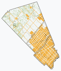
Caledon (/ˈkælədən/; 2021 population 76,581) is a town in the Regional Municipality of Peel in the Greater Toronto Area of Ontario, Canada. The name comes from a shortened form of Caledonia, the Roman name for what is now Scotland.[6] Caledon is primarily rural with a number of hamlets and small villages, but also contains the larger community of Bolton (population 26,795) in its southeastern quadrant, adjacent to York Region.[7] Some spillover urbanization also occurs in the south bordering the City of Brampton.
Caledon is the northernmost of three municipalities of Peel Region. The town is northwest of Brampton. According to Statistics Canada the land area is 688 km2 (266 sq mi)[2] and, according to the city the area is 696.04 km2 (268.74 sq mi),[3] which makes Caledon the largest municipality by area in the Greater Toronto Area.
- ^ "Caledon". Geographical Names Data Base. Natural Resources Canada.
- ^ a b c Cite error: The named reference
2021censuswas invoked but never defined (see the help page). - ^ a b Town of Caledon, Open Data. "Town of Caledon Open Data". Caledon Boundary. Town of Caledon. Retrieved 26 June 2024.
- ^ 43° 51' 44" N, 80° 8' 13" W, as per Google Earth
- ^ 43° 49' 15" N, 79° 43' 34" W, as per Google Earth
- ^ Hamilton, William (1978). The Macmillan Book of Canadian Place Names. Toronto: Macmillan. p. 139. ISBN 0-7715-9754-1.
- ^ "Bolton, Ontario (Population Centre)". Census Profile, Canada 2021 Census. Statistics Canada. 9 February 2022. Retrieved 12 February 2022.


