| Calfpasture River | |
|---|---|
 | |
| Location | |
| Country | United States |
| State | Virginia |
| County | Rockbridge County, Augusta County |
| Physical characteristics | |
| Source | Gordons Peak |
| • location | Allegheny Mountains, Augusta County, Virginia |
| • coordinates | 38°20′32″N 79°18′15″W / 38.34222°N 79.30417°W[1] |
| • elevation | 3,460 ft (1,050 m)[2] |
| Mouth | Maury River |
• location | Near Goshen, Rockbridge County, Virginia |
• coordinates | 37°56′57″N 79°27′34″W / 37.94917°N 79.45944°W[1] |
• elevation | 1,345 ft (410 m)[3] |
| Length | 41 mi (66 km)[4] |
| Basin size | 144 sq mi (370 km2)[5] |
| Discharge | |
| • location | Goshen[5] |
| • average | 169 cu ft/s (4.8 m3/s)[5] |
| • minimum | 0 cu ft/s (0 m3/s) |
| • maximum | 21,900 cu ft/s (620 m3/s) |
| Basin features | |
| Tributaries | |
| • left | Little Calfpasture River |
| • right | Hamilton Branch, Brattons Run |
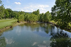
The Calfpasture River is a river in the U.S. state of Virginia. It flows about 41.0 miles (66.0 km)[4] from its source, Gordons Peak in the Allegheny Mountains, to its confluence with the Little Calfpasture River, forming the Maury River. Via the Maury, the Calfpasture's waters flow into the James River, thence Chesapeake Bay and the Atlantic Ocean.
According to the U.S. Board on Geographic Names, variant names of the Calfpasture River include the Big Calfpasture River, Calf Pasture River, Great Calfpasture River, and North River.[1]
- ^ a b c U.S. Geological Survey Geographic Names Information System: Calfpasture River
- ^ Source elevation derived from Google Earth search using GNIS source coordinates.
- ^ Mouth elevation derived from Google Earth search using GNIS mouth coordinates.
- ^ a b U.S. Geological Survey. National Hydrography Dataset high-resolution flowline data. The National Map Archived 2012-03-29 at the Wayback Machine, accessed April 1, 2011
- ^ a b c "Water-Data Report 2005: James River Basin" (pdf). United States Geological Survey (USGS). 2005.
