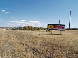
Calhan, Colorado | |
|---|---|
| Town of Calhan[1] | |
 | |
 Location of the Town of Calhan in El Paso County, Colorado | |
| Coordinates: 39°02′04″N 104°17′58″W / 39.03444°N 104.29944°W[2] | |
| Country | |
| State | |
| County | El Paso County[1] |
| Incorporated | May 10, 1919[3] |
| Government | |
| • Type | Statutory town[1] |
| Area | |
| • Total | 2.144 km2 (0.828 sq mi) |
| • Land | 2.144 km2 (0.828 sq mi) |
| • Water | 0.000 km2 (0.000 sq mi) |
| Elevation | 1,991 m (6,532 ft) |
| Population | |
| • Total | 762 |
| • Density | 356/km2 (921/sq mi) |
| Time zone | UTC−07:00 (MST) |
| • Summer (DST) | UTC−06:00 (MDT) |
| ZIP code | 80808[5] |
| Area code | 719 |
| FIPS code | 08-11260 |
| GNIS feature ID | 2413149[2] |
| Major Highways | |
| Website | www |
The Town of Calhan is a statutory town located in El Paso County, Colorado, United States.[1] The town population was 762 at the 2020 United States Census.[4] Calhan is a part of the Colorado Springs, CO Metropolitan Statistical Area and the Front Range Urban Corridor. The town straddles U.S. Highway 24. With Calhan sitting at an elevation of 6,535 feet (1,992 meters) above sea level, Calhan is the highest non-mountain town in the United States.[6]
- ^ a b c d e "Active Colorado Municipalities". Colorado Department of Local Affairs. Retrieved October 15, 2021.
- ^ a b c U.S. Geological Survey Geographic Names Information System: Calhan, Colorado
- ^ "Colorado Municipal Incorporations". State of Colorado, Department of Personnel & Administration, Colorado State Archives. December 1, 2004. Retrieved September 2, 2007.
- ^ a b c "Decennial Census P.L. 94-171 Redistricting Data". United States Census Bureau, United States Department of Commerce. August 12, 2021. Retrieved September 7, 2021.
- ^ "ZIP Code Lookup". United States Postal Service. Archived from the original (JavaScript/HTML) on September 3, 2007. Retrieved September 4, 2007.
- ^ "Calhan, Colorado". Uncover Colorado. Retrieved September 23, 2020.
