Calhoun County | |
|---|---|
 | |
 Location within the U.S. state of Arkansas | |
 Arkansas's location within the U.S. | |
| Coordinates: 33°34′15″N 92°31′25″W / 33.570833333333°N 92.523611111111°W | |
| Country | |
| State | |
| Founded | December 6, 1850 |
| Named for | John C. Calhoun |
| Seat | Hampton |
| Largest city | Hampton |
| Area | |
• Total | 632 sq mi (1,640 km2) |
| • Land | 629 sq mi (1,630 km2) |
| • Water | 3.8 sq mi (10 km2) 0.6% |
| Population (2020) | |
• Total | 4,739 |
| • Density | 7.5/sq mi (2.9/km2) |
| Time zone | UTC−6 (Central) |
| • Summer (DST) | UTC−5 (CDT) |
| Congressional district | 4th |
| Website | calhouncounty |
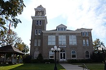
Calhoun County is a county located in the south central part of the U.S. state of Arkansas. As of the 2020 census, the population was 4,739,[1] making it the least populous county in Arkansas. The county seat is Hampton.[2] Calhoun County is Arkansas's 55th county, formed on December 6, 1850, and named for John C. Calhoun, a Vice President of the United States.
The county is part of the Camden, AR Micropolitan Statistical Area.
- ^ "Census - Geography Profile: Calhoun County, Arkansas". United States Census Bureau. Retrieved January 19, 2023.
- ^ "Find a County". National Association of Counties. Archived from the original on May 31, 2011. Retrieved June 7, 2011.