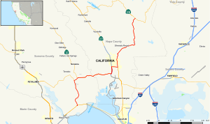
 Map of western California with SR 121 highlighted in red | ||||
| Route information | ||||
| Maintained by Caltrans | ||||
| Length | 33.567 mi[1] (54.021 km) | |||
| Major junctions | ||||
| South end | ||||
| ||||
| North end | ||||
| Location | ||||
| Country | United States | |||
| State | California | |||
| Counties | Sonoma, Napa | |||
| Highway system | ||||
| ||||
State Route 121 (SR 121) is a state highway in the U.S. state of California. It runs through the Wine Country region of Sonoma and Napa counties. Its southern terminus is at State Route 37 at Sears Point, and its northern terminus is at State Route 128 near Lake Berryessa. SR 121 passes through the Carneros region of the southern Sonoma Valley and Napa Valley.
