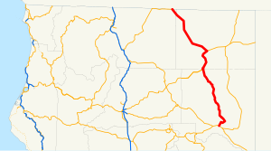
 SR 139 highlighted in red | ||||
| Route information | ||||
| Maintained by Caltrans | ||||
| Length | 143.26 mi[1][2] (230.55 km) | |||
| History | State highway in ca. 1940 and 1959; numbered by 1946 | |||
| Tourist routes | ||||
| Major junctions | ||||
| South end | ||||
| North end | ||||
| Location | ||||
| Country | United States | |||
| State | California | |||
| Counties | Lassen, Modoc, Siskiyou | |||
| Highway system | ||||
| ||||
State Route 139 (SR 139) is a state highway in the U.S. state of California. Running from SR 36 in Susanville north to Oregon Route 39 at the Oregon state line, it forms part of the shortest route between Reno, Nevada, and Klamath Falls, Oregon. SR 139 cuts through much of Modoc National Forest and passes near Antelope Mountain and Tule Lake. North of SR 299 near Canby, SR 139 was built by the federal government and turned over to the state in about 1940; the remainder was built by a joint highway district of Lassen and Modoc Counties, completed in 1956, and given to the state in 1959.
