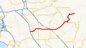
 SR 140 highlighted in red | ||||
| Route information | ||||
| Maintained by Caltrans | ||||
| Length | 101.645 mi[1] (163.582 km) SR 140 is broken into pieces, and the length does not reflect the overlaps that would be required to make the route continuous. | |||
| Tourist routes | ||||
| Major junctions | ||||
| West end | ||||
| East end | Yosemite National Park | |||
| Location | ||||
| Country | United States | |||
| State | California | |||
| Counties | Merced, Mariposa | |||
| Highway system | ||||
| ||||
State Route 140 (SR 140) is a state highway in the U.S. state of California, 102 miles (164 km) in length. It begins in the San Joaquin Valley at Interstate 5 near Gustine, and runs east into Sierra Nevada, terminating in Yosemite National Park.
- ^ Cite error: The named reference
trucklistwas invoked but never defined (see the help page). - ^ California Department of Transportation (August 2019). "Officially Designated State Scenic Highways and Historic Parkways" (XLSX). Sacramento: California Department of Transportation. Retrieved March 27, 2019.
