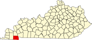
Calloway County | |
|---|---|
 Calloway County courthouse in Murray | |
 Location within the U.S. state of Kentucky | |
 Kentucky's location within the U.S. | |
| Coordinates: 36°37′N 88°16′W / 36.62°N 88.27°W | |
| Country | |
| State | |
| Founded | November 3, 1822 |
| Named for | Richard Callaway |
| Seat | Murray |
| Largest city | Murray |
| Area | |
• Total | 411 sq mi (1,060 km2) |
| • Land | 385 sq mi (1,000 km2) |
| • Water | 26 sq mi (70 km2) 6.3% |
| Population (2020) | |
• Total | 37,103 |
• Estimate (2023) | 38,280 |
| • Density | 90/sq mi (35/km2) |
| Time zone | UTC−6 (Central) |
| • Summer (DST) | UTC−5 (CDT) |
| Congressional district | 1st |
| Website | callowaycountyky |
Calloway County is a county located on the southwest border of the U.S. Commonwealth of Kentucky. As of the 2020 census, the population was 37,103.[1] Its county seat is Murray.[2] The county was founded in November 1822 and named for Colonel Richard Callaway, one of the founders of Boonesborough.[3] Calloway County comprises the Murray, KY Micropolitan Statistical Area. As of July 18, 2012[update] Calloway County is a moist county: the sale of alcohol in the county is prohibited, with the exception of the city of Murray.
- ^ "State & County QuickFacts". United States Census Bureau. Retrieved July 7, 2022.
- ^ "Find a County". National Association of Counties. Archived from the original on May 31, 2011. Retrieved June 7, 2011.
- ^ "Calloway County". The Kentucky Encyclopedia. 2000. Archived from the original on September 30, 2018. Retrieved August 21, 2014.

