This article has multiple issues. Please help improve it or discuss these issues on the talk page. (Learn how and when to remove these messages)
|
Calvados | |
|---|---|
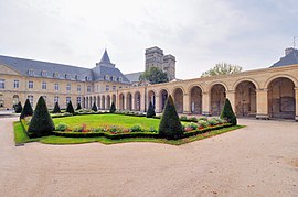
From top down, left to right: Abbaye aux Dames in Caen, Bayeux's historic centre, Omaha Beach and timber framing house in Boissey | |
 Location of Calvados in France | |
| Coordinates: 49°02′N 0°15′E / 49.033°N 0.250°E | |
| Country | France |
| Region | Normandy |
| Prefecture | Caen |
| Subprefectures | Bayeux Lisieux Vire-Normandie |
| Government | |
| • President of the Departmental Council | Jean-Léonce Dupont[1] (New Centre) |
| Area | |
• Total | 5,535 km2 (2,137 sq mi) |
| Population (2021)[2] | |
• Total | 700,633 |
| • Rank | 34th |
| • Density | 130/km2 (330/sq mi) |
| Time zone | UTC+1 (CET) |
| • Summer (DST) | UTC+2 (CEST) |
| ISO 3166 code | FR-14 |
| Department number | 14 |
| Arrondissements | 4 |
| Cantons | 25 |
| Communes | 528 |
| ^1 French Land Register data, which exclude estuaries, and lakes, ponds, and glaciers larger than 1 km2 | |
Calvados (UK: /ˈkælvədɒs/, US: /-doʊs, ˌkælvəˈdoʊs, ˌkɑːlvəˈ-/, French: [kalvados] )[needs Norman IPA] is a department in the Normandy region in northwestern France.[3] It takes its name from a cluster of rocks off the Normandy coast. In 2019, it had a population of 694,905.[4]
- ^ "Répertoire national des élus: les conseillers départementaux". data.gouv.fr, Plateforme ouverte des données publiques françaises (in French). 4 May 2022.
- ^ "Téléchargement du fichier d'ensemble des populations légales en 2021" (in French). The National Institute of Statistics and Economic Studies. 28 December 2023.
- ^ Chisholm, Hugh, ed. (1911). . Encyclopædia Britannica (11th ed.). Cambridge University Press.
- ^ Populations légales 2019: 14 Calvados Archived 11 November 2022 at the Wayback Machine, INSEE


