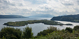
 Calve Island viewed from Tobermory Golf Course | |
| Location | |
|---|---|
| OS grid reference | NM521546 |
| Coordinates | 56°37′N 6°02′W / 56.62°N 6.04°W |
| Physical geography | |
| Island group | Mull |
| Area | 72 ha (180 acres) |
| Area rank | 171= [1] |
| Highest elevation | 20 m (66 ft) |
| Administration | |
| Council area | Argyll and Bute |
| Country | Scotland |
| Sovereign state | United Kingdom |
| Demographics | |
| Population | 0 |
| References | [2][3][4] |
Calve Island is an uninhabited low-lying island off the east coast of the Isle of Mull in Argyll and Bute on the west coast of Scotland. A whitewashed farmhouse with substantial outbuildings stands on the western shore, used as a summer residence.[5] The island is 1+1⁄4 miles (2 kilometres) in length, and 1⁄2 mile (800 metres) wide at its widest point.[6] Calve is owned by the Cotton family who make use of it in the summer months.[7]

- ^ Area and population ranks: there are c. 300 islands over 20 ha in extent and 93 permanently inhabited islands were listed in the 2011 census.
- ^ General Register Office for Scotland (28 November 2003) Scotland's Census 2001 – Occasional Paper No 10: Statistics for Inhabited Islands. Retrieved 26 February 2012.
- ^ Haswell-Smith (2004) p. 79
- ^ Get-a-map (Map). Ordnance Survey.
- ^ Haswell-Smith (2004) p.91
- ^ Google Maps
- ^ Haswell-Smith (2004) p. 91

