| Camooweal Queensland | |||||||||||||||
|---|---|---|---|---|---|---|---|---|---|---|---|---|---|---|---|
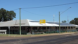
 Post Office Hotel, 2019 | |||||||||||||||
| Coordinates | 19°55′16″S 138°07′10″E / 19.9211°S 138.1194°E | ||||||||||||||
| Population | 236 (2021 census)[1] | ||||||||||||||
| • Density | 0.02475/km2 (0.06409/sq mi) | ||||||||||||||
| Established | 1884 | ||||||||||||||
| Postcode(s) | 4828 | ||||||||||||||
| Elevation | 231.2 m (759 ft) | ||||||||||||||
| Area | 9,537.0 km2 (3,682.3 sq mi) | ||||||||||||||
| Time zone | AEST (UTC+10:00) | ||||||||||||||
| Location |
| ||||||||||||||
| LGA(s) | City of Mount Isa | ||||||||||||||
| State electorate(s) | Traeger | ||||||||||||||
| Federal division(s) | Kennedy | ||||||||||||||
| |||||||||||||||
| |||||||||||||||
Camooweal is an outback town and locality in the City of Mount Isa, Queensland, Australia.[2][3] The locality is on the Queensland border with the Northern Territory. In the 2021 census, the locality of Camooweal had a population of 236 people.[1]
- ^ a b Cite error: The named reference
Census2021was invoked but never defined (see the help page). - ^ "Camooweal – town in City of Mount Isa (entry 5880)". Queensland Place Names. Queensland Government. Retrieved 19 December 2020.
- ^ "Camooweal – locality in City of Mount Isa (entry 42312)". Queensland Place Names. Queensland Government. Retrieved 19 December 2020.
