Campbell County | |
|---|---|
 | |
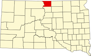
 Location within the U.S. state of South Dakota | |
 South Dakota's location within the U.S. | |
| Coordinates: 45°46′N 100°03′W / 45.76°N 100.05°W | |
| Country | |
| State | |
| Founded | 1873 (created) 1884 (organized) |
| Seat | Mound City |
| Largest city | Herreid |
| Area | |
• Total | 771 sq mi (2,000 km2) |
| • Land | 734 sq mi (1,900 km2) |
| • Water | 37 sq mi (100 km2) 4.8% |
| Population (2020) | |
• Total | 1,377 |
• Estimate (2023) | 1,340 |
| • Density | 1.8/sq mi (0.69/km2) |
| Time zone | UTC−6 (Central) |
| • Summer (DST) | UTC−5 (CDT) |
| Congressional district | At-large |
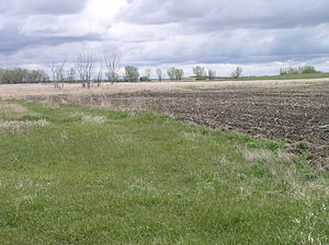
Campbell County is a county in the U.S. state of South Dakota. As of the 2020 census, the population was 1,377,[1] making it the fourth-least populous county in South Dakota. Its county seat is Mound City.[2] The county was created in 1873 and organized in 1884.[3] It was named for Norman B. Campbell, a Dakota Territory legislator in 1873 and son of General Charles T. Campbell.[4]
- ^ "State & County QuickFacts". United States Census Bureau. Retrieved March 21, 2024.
- ^ "Find a County". National Association of Counties. Archived from the original on May 31, 2011. Retrieved June 7, 2011.
- ^ "Dakota Territory, South Dakota, and North Dakota: Individual County Chronologies". Dakota Territory Atlas of Historical County Boundaries. The Newberry Library. 2006. Archived from the original on April 2, 2018. Retrieved March 29, 2015.
- ^ Legislative Manual, South Dakota, 2005, p. 596