Canaan, Connecticut | |
|---|---|
 South Canaan Congregational Church | |
| Coordinates: 41°57′42″N 73°18′30″W / 41.96167°N 73.30833°W | |
| Country | |
| U.S. state | |
| County | Litchfield |
| Region | Northwest Hills |
| Incorporated | 1739 |
| Government | |
| • Type | Selectman-town meeting |
| • First Selectman | Henry Todd (R) |
| • Selectmen | David Barger (D) Greg Marlowe (R) |
| Area | |
| • Total | 33.24 sq mi (86.08 km2) |
| • Land | 32.91 sq mi (85.24 km2) |
| • Water | 0.32 sq mi (0.84 km2) |
| Elevation | 656 ft (200 m) |
| Population (2020) | |
| • Total | 1,080 |
| • Density | 32/sq mi (13/km2) |
| Time zone | UTC−5 (EST) |
| • Summer (DST) | UTC−4 (EDT) |
| ZIP code | 06031 |
| Area code(s) | 860/959 |
| FIPS code | 09-10940 |
| GNIS feature ID | 0213402 |
| Website | www |
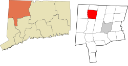
Canaan is a town in Litchfield County, Connecticut, United States. The population was 1,080 at the 2020 census,[1] down from 1,234 at the 2010 census. The town is part of the Northwest Hills Planning Region. The town of Canaan is often referred to locally by the name of its principal settlement, Falls Village.[2]
- ^ "Census - Geography Profile: Canaan town, Litchfield County, Connecticut". United States Census Bureau. Retrieved November 27, 2021.
- ^ Early Historical Highlights of the Town of Canaan (Commonly Known As Falls Village) Archived April 5, 2009, at the Wayback Machine, Town of Canaan website


