This article needs additional citations for verification. (January 2011) |
| Canadian Rockies | |
|---|---|
| Rocheuses canadiennes (French) | |
 Snow Dome, Mt. Forbes, the Lyells, and others from Mt. Kitchener at the edge of the Columbia Icefield | |
| Highest point | |
| Peak | Mount Robson |
| Elevation | 3,954 m (12,972 ft) |
| Coordinates | 53°06′38″N 119°09′21″W / 53.11056°N 119.15583°W |
| Dimensions | |
| Length | 1,460 km (910 mi)[1] |
| Width | 180 km (110 mi)[1] |
| Area | 194,000 km2 (75,000 sq mi)[1] |
| Geography | |
| Country | Canada |
| Provinces | |
| Parent range | Pacific Cordillera |
| Geology | |
| Orogeny | Sevier orogeny[2] |
| Rock type | Sedimentary rock |

The Canadian Rockies (French: Rocheuses canadiennes) or Canadian Rocky Mountains, comprising both the Alberta Rockies and the British Columbian Rockies, is the Canadian segment of the North American Rocky Mountains. It is the easternmost part of the Canadian Cordillera, which is the northern segment of the North American Cordillera, the expansive system of interconnected mountain ranges between the Interior Plains and the Pacific Coast that runs northwest–southeast from central Alaska to the Isthmus of Tehuantepec in Mexico.
Canada officially defines the Rocky Mountains system as the mountain chains east of the Rocky Mountain Trench extending from the Liard River valley in northern British Columbia to the Albuquerque Basin in New Mexico, not including the Mackenzie, Richardson and British Mountains/Brooks Range in Yukon and Alaska (which are all included as the "Arctic Rockies" in the United States' definition of the Rocky Mountains system).[3] The Canadian Rockies, being the northern segment of this chain, is thus defined as comprising the central-eastern section of the North American Cordillera, between the Prairies of Alberta and the Liard Plain of northeastern British Columbia to the east and the Interior Mountains/Plateau and Columbia Mountains to the west. It is divided into the Northern Rockies (which is further subdivided into the Muskwa and Hart Ranges) and Continental Ranges, separated by the McGregor River valley, the McGregor Pass and the Kakwa River valley.
The southern end of the Canadian Rockies extends into the U.S. state of Montana at various sites such as the Wilson Range, Upper Waterton Lake, Boundary Creek, Cameron Lake, Forum Peak, Long Knife Peak, North Fork Flathead River and Frozen Lake. In geographic terms, the boundary is at the Canada–United States border on 49th parallel north, but in geological terms it might be considered to be at Marias Pass in northern Montana.
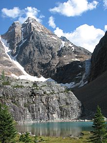
The Canadian Rockies have numerous high peaks and ranges, such as Mount Robson (3,954 metres; 12,972 feet) and Mount Columbia (3,747 m; 12,293 ft). The Canadian Rockies are composed of shale and limestone. Much of the range is protected by national and provincial parks, several of which collectively comprise a World Heritage Site.
- ^ a b c Cite error: The named reference
Gadd 1995was invoked but never defined (see the help page). - ^ "Laramide and Sevier orogenies (PLATE TECTONICS) – g17" (PDF). geowords.com. p. 423. Archived (PDF) from the original on 2020-10-08. Retrieved 2017-08-20.
- ^ Madole, Richard F.; Bradley, William C.; Loewenherz, Deborah S.; Ritter, Dale F.; Rutter, Nathaniel W.; Thorn, Colin E. (1987). "Rocky Mountains". In Graf, William L. (ed.). Geomorphic Systems of North America. Decade of North American Geology. Vol. 2 (Centennial Special ed.). Geological Society of America (published 1987-01-01). pp. 211–257. doi:10.1130/DNAG-CENT-v2.211. ISBN 9780813754147. Retrieved 2021-06-22.
