Canajoharie, New York | |
|---|---|
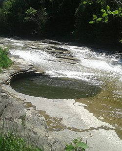
 The "pot that washes itself", also known as Foley’s Water Spout is a pothole located just south of the Village of Canajoharie on the Canajoharie Creek | |
 Location within Montgomery County and the state of New York. | |
| Coordinates: 42°54′22″N 74°34′19″W / 42.90611°N 74.57194°W | |
| Country | United States |
| State | New York |
| County | Montgomery |
| Government | |
| • Type | Town Council |
| • Town Supervisor | Austin Countryman (R) |
| • Town Council | Members |
| Area | |
• Total | 43.10 sq mi (111.63 km2) |
| • Land | 42.60 sq mi (110.34 km2) |
| • Water | 0.50 sq mi (1.29 km2) |
| Population | |
• Total | 3,730 |
• Estimate (2016)[3] | 3,613 |
| • Density | 84.81/sq mi (32.74/km2) |
| Time zone | UTC-5 (Eastern (EST)) |
| • Summer (DST) | UTC-4 (EDT) |
| FIPS code | 36-057-12122 |
Canajoharie (/ˌkænədʒəˈhɛəri/) is a town in Montgomery County, New York, United States. The population was 3,730 in 2010.[2] Canajoharie is located south of the Mohawk River on the southern border of the county. The Erie Canal passes along the northern town line. There is also a village of Canajoharie in the town. Both are east of Utica and west of Amsterdam.
These were settled as European-American jurisdictions, named for the historic Mohawk village of the same name, which was also known as the Mohawk Upper Castle.
- ^ "2016 U.S. Gazetteer Files". United States Census Bureau. Retrieved July 5, 2017.
- ^ a b "Geographic Identifiers: 2010 Demographic Profile Data (G001): Canajoharie town, Montgomery County, New York". U.S. Census Bureau, American Factfinder. Archived from the original on February 12, 2020. Retrieved November 15, 2012.
- ^ Cite error: The named reference
USCensusEst2016was invoked but never defined (see the help page).