| Canajoharie Creek | |
|---|---|
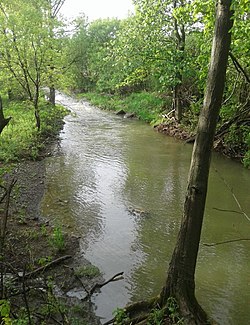
 Canajoharie Creek by Mill Road southwest of the hamlet of Sprout Brook | |
| Location | |
| Country | United States |
| State | New York |
| Region | Central New York |
| Counties | Otsego, Montgomery |
| Towns | Cherry Valley, Canajoharie |
| Physical characteristics | |
| Source | |
| • location | N of Cherry Valley, New York |
| • coordinates | 42°48′38″N 74°44′34″W / 42.81056°N 74.74278°W[1] |
| Mouth | Mohawk River |
• location | Canajoharie, New York |
• coordinates | 42°54′32″N 74°34′11″W / 42.90889°N 74.56972°W[1] |
• elevation | 285 ft (87 m)[1] |
| Basin size | 69.22 sq mi (179.3 km2)[2] |
| Basin features | |
| Tributaries | |
| • left | Takaharawa Brook, Bowmans Creek |
| • right | Van Deusen Brook, Tri County Creek, Brimstone Creek |
| Waterfalls | Judds Falls, Canajoharie Falls |
The Canajoharie Creek (/ˌkænədʒəˈhɛəri/) is a river that flows into the Mohawk River in the Village of Canajoharie in the U.S. State of New York.[3] The name "Canajoharie" is a Mohawk language term meaning "the pot that washes itself", referring to the "Canajoharie Boiling Pot", a 20-foot (6.1 m) wide and 10-foot (3.0 m) deep pothole in the Canajoharie Creek, just south of the village of Canajoharie. Bowmans Creek is one main tributary that enters the creek east of the Hamlet of Sprout Brook.[4] The other main tributary is Brimstone Creek which enters the creek north-northwest of the Village of Ames.[5]
- ^ a b c "Canajoharie Creek". Geographic Names Information System. United States Geological Survey, United States Department of the Interior. Retrieved 2017-10-29.
- ^ "Annual Report of the State Engineer and Surveyor". New York State Engineer and Surveyor. 1923. Archived from the original on 1 August 2021. Retrieved 16 May 2019.
- ^ "Canajoharie Creek". usgs.gov. usgs. Archived from the original on 19 April 2017. Retrieved 16 April 2017.
- ^ "Bowmans Creek". Geographic Names Information System. United States Geological Survey, United States Department of the Interior. Retrieved 2018-05-19.
- ^ Cite error: The named reference
brimstonewas invoked but never defined (see the help page).

