Canal Flats | |
|---|---|
| Village of Canal Flats | |
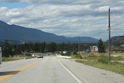
 Highway northward, Canal Flats, 2013 | |
Location of Canal Flats in British Columbia | |
| Coordinates: 50°09′36″N 115°48′31″W / 50.16000°N 115.80861°W | |
| Country | Canada |
| Province | British Columbia |
| Region | Columbia Valley/East Kootenay |
| Regional district | East Kootenay |
| Incorporated | 2004 |
| Government | |
| • Governing body | Canal Flats Village Council |
| Area | |
| • Total | 11.07 km2 (4.27 sq mi) |
| Population (2021) | |
| • Total | 802 |
| • Density | 72/km2 (190/sq mi) |
| Time zone | UTC-7 (MST) |
| Area codes | 250, 778, 236, & 672 |
| Highways | |
| Waterways | Columbia Lake, Columbia River, Kootenay River |
| Website | Official website |
Canal Flats is a village municipality in the East Kootenay region of southeastern British Columbia.[1] This Columbia Valley community lies between the southern end of Columbia Lake and the northwest shore of the Kootenay River. The locality, on Highway 93/95, is by road about 83 kilometres (52 mi) north of Cranbrook and 165 kilometres (103 mi) southeast of Golden.
