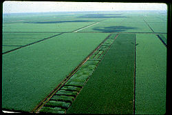
Canal Point, Florida | |
|---|---|
 | |
| Nickname: CP | |
 | |
| Coordinates: 26°51′43″N 80°37′50″W / 26.86194°N 80.63056°W | |
| Country | |
| State | |
| County | |
| Area | |
• Total | 1.39 sq mi (3.60 km2) |
| • Land | 1.39 sq mi (3.60 km2) |
| • Water | 0.00 sq mi (0.00 km2) |
| Elevation | 13 ft (4 m) |
| Population (2020) | |
• Total | 344 |
| • Density | 247.13/sq mi (95.42/km2) |
| Time zone | UTC-5 (Eastern (EST)) |
| • Summer (DST) | UTC-4 (EDT) |
| ZIP code | 33438[2] |
| Area code(s) | 561, 728 |
| FIPS code | 12-10100[3] |
| GNIS feature ID | 0279964[4] |
Canal Point is a census-designated place (CDP) and unincorporated community in Palm Beach County, Florida, United States. It is part of the Miami metropolitan area of South Florida despite its local culture and location being way more similar to the Florida Heartland. Canal Point has a population of 344 people counted in the 2020 US census.
The land was originally inhabited by the Calusa tribe until 1650 CE. White settlers began occupying the area in 1909, establishing an agrarian community that currently still relies heavily on agriculture, especially sugar from sugarcane crops. The completion of the West Palm Beach Canal in 1917 allowed crops to be shipped by boat to West Palm Beach and then to other areas of the country, while construction of Conners Highway in 1924 resulted in crops being transported by motor vehicle. The CDP is very small with very little infrastructure.
- ^ "2020 U.S. Gazetteer Files". United States Census Bureau. Retrieved October 31, 2021.
- ^ "Canal Point, FL ZIP Code". zipdatamaps.com. 2023. Retrieved July 19, 2023.
- ^ "U.S. Census website". United States Census Bureau. Retrieved January 31, 2008.
- ^ "US Board on Geographic Names". United States Geological Survey. October 25, 2007. Retrieved January 31, 2008.