| Canal d'Ille-et-Rance | |
|---|---|
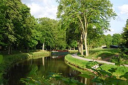
 The Canal d'Ille-et-Rance at Chevaigné | |
| Specifications | |
| Length | 79 km (49 mi) [1] |
| Locks | 47 [1][2] |
| History | |
| Construction began | 1804 |
| Date of first use | 1832 |
| Geography | |
| Direction | North/South |
| Start point | Vilaine at Rennes[1] |
| End point | Dinan[1] |
The Canal d'Ille-et-Rance (French pronunciation: [kanal dil e ʁɑ̃s], literally Canal of Ille and Rance; Breton: Kanol an Il hag ar Renk) is a 79 km (49 mi) long canal in northwestern France connecting Dinan to the Vilaine at Rennes, thus forming part of the English Channel/Atlantic Ocean link which has long been used by yachtsmen, but has also become increasingly popular as a cruising waterway in its own right.[3] It takes its name from the rivers Ille and Rance. Several hire firms are based on the canal or its connecting waterways. From Dinan the navigation continues in the semi-tidal river Rance for a further 6 km to Le Châtelier lock, below which navigation continues in the tidal Rance maritime. The canal has a summit level 7 km in length at an altitude of 65m, and in times of drought some restrictions may have to be imposed on the use of locks.[3]
- ^ a b c d Jefferson, David (2009). Through the French Canals. Adlard Coles Nautical. p. 275. ISBN 978-1-4081-0381-4.
- ^ Fluviacarte, Canal d'Ille-et-Rance
- ^ a b Edwards-May, David (2010). Inland Waterways of France. St Ives, Cambs., UK: Imray. pp. 90–94. ISBN 978-1-846230-14-1.
