| Candleston Castle | |
|---|---|
| Merthyr Mawr, Wales | |
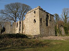
 Candleston Castle, view from south of the 14th-century tower, to rear. Left the hall and domestic range, from the middle of which projects to left the 17th-century west wing. To right of the tower is the stable block, c. 1800. | |
| Coordinates | 51°28′57″N 3°37′38″W / 51.4825°N 3.6273°W |
| Grid reference | grid reference SS871772 |
| Site history | |
| Materials | Stone |
Candleston Castle (historically sometimes Candlestone Castle) is a 14th-century fortified manor house, in ruins since the 19th century. It is 0.75 miles (1.2 km) southwest of Merthyr Mawr, Glamorgan, Wales, now Bridgend County Borough and just 0.75 miles (1.2 km) northwest of Ogmore Castle, separated by the River Ogmore. Candleston's original long and narrow rectangular structure lay across the western end of a low narrow promontory, suggesting a defensive position. The castle is believed to be named after the Norman family of Cantilupe, thought to be its first feudal tenants.
