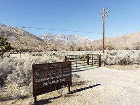
| Canebrake Ecological Reserve | |
|---|---|
 Access gate along SR 178 | |
| Location | Kern County, California |
| Nearest city | Ridgecrest |
| Coordinates | 35°43′40″N 118°10′26″W / 35.72778°N 118.17389°W[1] |
| Area | 6,700 acres (27 km2) |
| Established | 1996 |
| Governing body | California Department of Fish and Game |
Canebrake Ecological Reserve is a 6,700-acre (27 km2)[2] nature reserve in the South Fork Valley of Kern County, 20 miles (32 km) east of Lake Isabella, California. It is located in the Southern Sierra Nevada region.
Historian Wallace M. Morgan, in History of Kern County, California, wrote that the South Fork Valley was the first area settled around 1846, and described the valley as "a fertile strip of bottomland that forms the most important of the mountain farming districts."[3] The first acreage purchased for reserve was part of the 129-year-old Bloomfield Ranch.
- ^ "Canebrake Creek". Geographic Names Information System. United States Geological Survey, United States Department of the Interior.
- ^ "Trip D-Canebrake Ecological Reserve". 2009 Field Trip Descriptions. Audubon Kern River Preserve. Archived from the original on 2008-06-02. Retrieved 2010-01-06.
- ^ Morgan, Wallace M. (1914). "History of Kern County, California". Los Angeles, California: Historic Record Company. p. 27.
