Canfield, Ohio | |
|---|---|
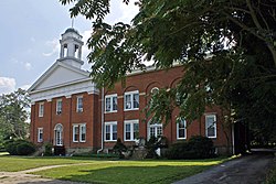
 Old Mahoning County Courthouse | |
 Location of Canfield in Mahoning County and in the State of Ohio | |
| Coordinates: 41°01′35″N 80°46′10″W / 41.02639°N 80.76944°W | |
| Country | United States |
| State | Ohio |
| County | Mahoning |
| Government | |
| • Type | Council-Manager |
| Area | |
• Total | 5.13 sq mi (13.30 km2) |
| • Land | 5.10 sq mi (13.22 km2) |
| • Water | 0.03 sq mi (0.08 km2) |
| Elevation | 1,116 ft (340 m) |
| Population (2020) | |
• Total | 7,699 |
• Estimate (2023)[3] | 7,610 |
| • Density | 1,508.42/sq mi (582.41/km2) |
| Time zone | UTC-5 (Eastern (EST)) |
| • Summer (DST) | UTC-4 (EDT) |
| ZIP code | 44406 |
| Area code(s) | 330, 234 |
| FIPS code | 39-11360[4] |
| GNIS feature ID | 2393729[2] |
| Website | http://www.ci.canfield.oh.us/ |
Canfield is a city in central Mahoning County, Ohio, United States. The population was 7,699 as of the 2020 census.[5] It is located at the intersection of U.S. Routes 62 and 224 about 8 miles (13 km) southwest of Youngstown and is a suburb of the Youngstown–Warren metropolitan area.[6]
- ^ "ArcGIS REST Services Directory". United States Census Bureau. Retrieved September 20, 2022.
- ^ a b U.S. Geological Survey Geographic Names Information System: Canfield, Ohio
- ^ "Annual Estimates of the Resident Population for Incorporated Places in Ohio: April 1, 2020 to July 1, 2023". United States Census Bureau. Retrieved June 8, 2024.
- ^ "U.S. Census website". United States Census Bureau. Retrieved January 31, 2008.
- ^ "QuickFacts: Canfield city, Ohio". census.gov. Retrieved September 13, 2021.
- ^ "Canfield Township | Mahoning County | Northeast, Ohio". Canfield Township.