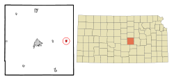
Canton, Kansas | |
|---|---|
 | |
 Location within McPherson County and Kansas | |
 | |
| Coordinates: 38°23′09″N 97°25′48″W / 38.38583°N 97.43000°W[1] | |
| Country | United States |
| State | Kansas |
| County | McPherson |
| Founded | 1870s |
| Platted | 1879 |
| Incorporated | 1880[2] |
| Named for | Canton, Ohio |
| Government | |
| • Type | Mayor–Council |
| • Mayor | Earl Maltbie |
| Area | |
| • Total | 0.50 sq mi (1.29 km2) |
| • Land | 0.50 sq mi (1.29 km2) |
| • Water | 0.00 sq mi (0.00 km2) |
| Elevation | 1,591 ft (485 m) |
| Population | |
| • Total | 685 |
| • Density | 1,400/sq mi (530/km2) |
| Time zone | UTC-6 (CST) |
| • Summer (DST) | UTC-5 (CDT) |
| ZIP code | 67428 |
| Area code | 620 |
| FIPS code | 20-10475 |
| GNIS ID | 2393735[1] |
| Website | cantonks.org |
Canton is a city in McPherson County, Kansas, United States.[1] As of the 2020 census, the population of the city was 685.[5] It is named after Canton, Ohio.[6]
- ^ a b c d U.S. Geological Survey Geographic Names Information System: Canton, Kansas
- ^ a b Cite error: The named reference
gov1was invoked but never defined (see the help page). - ^ Cite error: The named reference
gov2was invoked but never defined (see the help page). - ^ "2019 U.S. Gazetteer Files". United States Census Bureau. Retrieved July 24, 2020.
- ^ a b "Profile of Canton, Kansas in 2020". United States Census Bureau. Archived from the original on November 12, 2021. Retrieved November 12, 2021.
- ^ History of Canton; City of Canton.