Canyon County | |
|---|---|
 Boise River and Canal Bridge in Caldwell | |
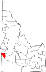
 Location within the U.S. state of Idaho | |
 Idaho's location within the U.S. | |
| Coordinates: 43°38′N 116°43′W / 43.63°N 116.71°W | |
| Country | |
| State | |
| Founded | March 7, 1891 |
| Seat | Caldwell |
| Largest city | Nampa |
| Area | |
| • Total | 604 sq mi (1,560 km2) |
| • Land | 587 sq mi (1,520 km2) |
| • Water | 16 sq mi (40 km2) 2.7% |
| Population (2020) | |
| • Total | 231,105 |
| • Estimate (2022) | 251,065 |
| • Density | 394/sq mi (152/km2) |
| Time zone | UTC−7 (Mountain) |
| • Summer (DST) | UTC−6 (MDT) |
| Congressional district | 1st |
| Website | www |
Canyon County is located in the U.S. state of Idaho. As of the 2020 Census, the population was 231,105,[1] which by 2022 was estimated to have risen to 251,065.[2] making it the second-most populous county in Idaho. The county seat is Caldwell,[3] and its largest city is Nampa. Canyon County is part of the Boise metropolitan area.
- ^ "State & County QuickFacts". United States Census Bureau. Retrieved January 15, 2024.
- ^ "Annual Estimates of the Resident Population for Counties: April 1, 2020 to July 1, 2022". United States Census Bureau. Retrieved January 15, 2024.
- ^ "Find a County". National Association of Counties. Archived from the original on May 31, 2011. Retrieved June 7, 2011.