Cap-Chat | |
|---|---|
 | |
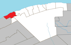
 Location within La Haute-Gaspésie RCM | |
| Coordinates: 49°06′N 66°41′W / 49.100°N 66.683°W[1] | |
| Country | Canada |
| Province | Quebec |
| Region | Gaspésie–Îles-de-la-Madeleine |
| RCM | La Haute-Gaspésie |
| Settled | 1815 |
| Constituted | March 15, 2000 |
| Government | |
| • Mayor | Marcel Soucy |
| • Federal riding | Gaspésie—Les Îles-de-la-Madeleine |
| • Prov. riding | Gaspé |
| Area | |
• Total | 208.99 km2 (80.69 sq mi) |
| • Land | 181.31 km2 (70.00 sq mi) |
| Population | |
• Total | 2,516 |
| • Density | 13.9/km2 (36/sq mi) |
| • Pop 2016-2021 | |
| • Dwellings | 1,405 |
| Time zone | UTC−5 (EST) |
| • Summer (DST) | UTC−4 (EDT) |
| Postal code(s) | |
| Area code(s) | 418 and 581 |
| Highways | |
| Website | ville |
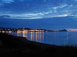
Cap-Chat is a town in the Canadian province of Québec, in the Regional County Municipality of Haute-Gaspésie, and in the administrative region of Gaspésie-Îles-de-la-Madeleine. Cap-Chat is found 16 kilometres (9.9 mi) west of Sainte-Anne-des-Monts. As of 2021[update], Cap-Chat's population is 2,516.[4]
In addition to Cap-Chat itself, the town's territory also includes the communities of Cap-Chat-Est, Capucins, and Petit-Fonds.
- ^ Cite error: The named reference
toponymiewas invoked but never defined (see the help page). - ^ a b "Répertoire des municipalités: Geographic code 04047". www.mamh.gouv.qc.ca (in French). Ministère des Affaires municipales et de l'Habitation. Retrieved 2024-08-12.
- ^ a b "Cap-Chat census profile". 2021 Census data. Statistics Canada. Retrieved 2024-08-02.
- ^ "Cap-Chat community profile". 2021 Census data. Statistics Canada. 15 November 2023. Retrieved 2024-08-02.
