Capdenac | |
|---|---|
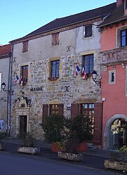
 The town hall in Capdenac | |
| Coordinates: 44°34′54″N 2°04′12″E / 44.5817°N 2.07°E | |
| Country | France |
| Region | Occitania |
| Department | Lot |
| Arrondissement | Figeac |
| Canton | Figeac-2 |
| Intercommunality | Grand-Figeac |
| Government | |
| • Mayor (2020–2026) | Guy Batherosse[1] |
| Area 1 | 10.90 km2 (4.21 sq mi) |
| Population (2021)[2] | 1,091 |
| • Density | 100/km2 (260/sq mi) |
| Time zone | UTC+01:00 (CET) |
| • Summer (DST) | UTC+02:00 (CEST) |
| INSEE/Postal code | 46055 /46100 |
| Elevation | 155–369 m (509–1,211 ft) (avg. 298 m or 978 ft) |
| 1 French Land Register data, which excludes lakes, ponds, glaciers > 1 km2 (0.386 sq mi or 247 acres) and river estuaries. | |
Capdenac (French pronunciation: [kapdənak]) is a commune in the Lot department in south-western France.
It has been inhabited since prehistoric times. At one time Capdenac was thought to be identifiable as the Gaulish settlement of Uxellodunum which was besieged by Julius Caesar,[3] but this theory has been discredited.[4]
- ^ "Répertoire national des élus: les maires". data.gouv.fr, Plateforme ouverte des données publiques françaises (in French). 2 December 2020.
- ^ "Populations légales 2021" (in French). The National Institute of Statistics and Economic Studies. 28 December 2023.
- ^ baron de Walckenaer, Géographie ancienne historique et comparée des Gaules cisalpine et transalpine, p 353, Paris, 1862 (1st edition 1839)
- ^ (2008-08-06), Uxellodunum: une nouvelle bataille en perspective, La Dépêche du Midi (ladepeche.fr) tr. Uxellodunum: A new battle in perspective (in French)


