Native name: truwana | |
|---|---|
 Cape Barren Island (center) from space, January 1997 | |
 Cape Barren Island (Tasmania) | |
| Geography | |
| Location | Bass Strait |
| Coordinates | 40°24′07″S 147°59′28″E / 40.402°S 147.991°E[1] |
| Area | 478.4 km2 (184.7 sq mi)[2] |
| Highest elevation | 715 m (2346 ft)[3] |
| Highest point | Mount Munro |
| Administration | |
Australia | |
| State | Tasmania |
| LGA | Municipality of Flinders Island |
| Largest settlement | The Corner (pop. 60) |
| Demographics | |
| Population | 66 (2016) |
| Pop. density | 0.14/km2 (0.36/sq mi) |
| Official name | Cape Barren Island,east coast lagoons |
| Designated | 16 November 1982 |
| Reference no. | 256[4] |
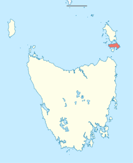
Cape Barren Island, officially truwana / Cape Barren Island,[5] is a 478-square-kilometre (185 sq mi) island in Bass Strait, off the north-east coast of Tasmania, Australia. It is the second-largest island of the Furneaux Group, with the larger Flinders Island to the north, and the smaller Clarke Island to the south. The highest point on the island is Mount Munro at 715 metres (2,346 ft).[3] Mount Munro is named after James Munro (c. 1779-1845), a former convict turned sealer who, from the 1820s, lived for more than 20 years with various indigenous women on nearby Preservation Island.
The south-eastern point of the island was named Cape Barren by Tobias Furneaux in HMS Adventure in March 1773.[6]
The island was gazetted as a locality of the Flinders Council in 1968. Its population numbered 66 in 2016,[7] most of them in the settlement called The Corner, on the north-west coast.[8]
Australia's only native goose, the Cape Barren goose, was first documented by European explorers on the island.[citation needed]
- ^ "Cape Barren Island, Tasmania (Islands & Reefs)". Gazetteer of Australia online. Geoscience Australia, Australian Government. Retrieved 29 December 2009.
- ^ "UN System-Wide Earthwatch Web Site Island Directory Tables Islands by Altitude". web page. United Nations Environment Programme (UNEP). 18 February 1998. Retrieved 4 June 2011.
- ^ a b "Island Directory Tables: Islands by Altitude". UN System-Wide Earthwatch Web Site. United Nations Environment Programme (UNEP). 18 February 1998. Retrieved 4 June 2011.
- ^ "Cape Barren Island,east coast lagoons". Ramsar Sites Information Service. Retrieved 25 April 2018.
- ^ "Survey Co-ordination (21403)" (PDF). Tasmanian Government Gazette. 5 February 2014. p. 155. Retrieved 3 January 2020.
- ^ Sprod, Dan (2005). "Furneaux, Tobias (1735–1781)". Australian Dictionary of Biography. Canberra: National Centre of Biography, Australian National University. ISBN 978-0-522-84459-7. ISSN 1833-7538. OCLC 70677943. Retrieved 5 May 2008.
- ^ "2016 Census QuickStats: Cape Barren Island". www.censusdata.abs.gov.au. Retrieved 16 April 2018.
- ^ "National Museum of Australia - Cape Barren Island, TAS". Archived from the original on 28 September 2007. Retrieved 10 June 2009.