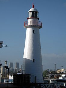
 Cape Bowling Green Lighthouse at the Australian National Maritime Museum, 2008 | |
 | |
| Location | Sydney, New South Wales, Australia |
|---|---|
| Coordinates | 33°52′07″S 151°11′57″E / 33.868689°S 151.199283°E |
| Tower | |
| Constructed | 1874 |
| Construction | hardwood frame clad with galvanized iron plates |
| Automated | 1920 |
| Height | 22 metres (72 ft)[1] |
| Shape | conical tower with balcony and lantern |
| Markings | white tower and lantern, red rail |
| Light | |
| Deactivated | 1987 |
| Focal height | 19 m (62 ft) |
| Lens | 3rd order Chance Brothers |
| Characteristic | Fl(4) W 20s |
| Current light | |
| Constructed | 1987 |
| Construction | metal skeletal tower |
| Height | 105 ft (32 m) |
| Shape | square pyramidal tower with balcony and lantern |
| Markings | white tower with red upper band |
| Operator | Australian Maritime Safety Authority |
| Focal height | 118 ft (36 m) |
| Range | 11 nmi (20 km; 13 mi) |
| Characteristic | Fl(4) W 20s |


Cape Bowling Green Light is an active lighthouse on Cape Bowling Green, a long headland ending in a long low sandspit, about 30 kilometres (19 mi) from Ayr, Queensland, Australia. The lighthouse is at the end of the headland, near the base of the sandspit. The first lighthouse at the location, established in 1874, was moved multiple times. It was prefabricated in Brisbane, shipped to the location, moved twice due to coastal erosion and finally transferred for display at the Australian National Maritime Museum at Darling Harbour in Sydney.[2][3]