This article needs additional citations for verification. (February 2017) |
Cape Breton County
| |
|---|---|
County | |
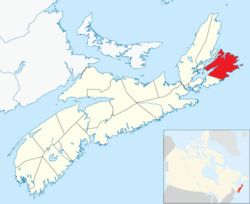
 Location of Cape Breton County, Nova Scotia | |
| Coordinates: 46°00′N 60°18′W / 46.0°N 60.3°W | |
| Country | Canada |
| Province | Nova Scotia |
| Municipality | Cape Breton Regional Municipality |
| Established | December 10, 1765 |
| Separated into Colony | 1784 |
| Reannexed to Nova Scotia | 1820 |
| Incorporated | April 17, 1879 |
| Amalgamated | August 1, 1995 |
| Electoral Districts Federal | Cape Breton—Canso / Sydney—Victoria |
| Provincial | Cape Breton Centre / Cape Breton North / Cape Breton Nova / Cape Breton South / Cape Breton West / Glace Bay |
| Government | |
| • Mayor-Warden | Amanda McDougall |
| • Council | Cape Breton Regional Council |
| Area | |
• Total | 2,470.62 km2 (953.91 sq mi) |
| Population (2006) | |
• Total | 109,330 |
| • Density | 44.3/km2 (115/sq mi) |
| Time zone | UTC-4 (AST) |
| Area code | 902 |
| Median Earnings* | $40,451 |
Part of a series about Places in Nova Scotia | |
Cape Breton County is one of eighteen counties in the Canadian province of Nova Scotia. It is located on Cape Breton Island.
From 1879 to 1995, the area of the county excluded from towns and cities was incorporated as the Municipality of the County of Cape Breton to provide local government services. Since 1995 the only municipality in the county has been a single-tier municipality called Cape Breton Regional Municipality. For statistical purposes, the First Nations reserves of Eskasoni 3 and Membertou 28B are included in the county, but are separate entities.