This article includes a list of general references, but it lacks sufficient corresponding inline citations. (March 2013) |
Cape Dezhnev
| |
|---|---|
 | |
| Coordinates: 66°4′45″N 169°39′7″W / 66.07917°N 169.65194°W | |
| Location | Chukotka, Russia |
| Offshore water bodies | Chukchi Sea |
| Area | |
| • Total | Russian Far East |
| Elevation | 741 m (2,431 ft) |


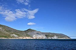
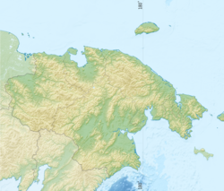
Cape Dezhnyov or Cape Dezhnev (Russian: мыс Дежнёва; Eskimo–Aleut: Tugnehalha; Inupiaq: Nuuġaq),[1] formerly known as East Cape or Cape Vostochny, is a cape that forms the easternmost mainland point of Asia. It is located on the Chukchi Peninsula in the very sparsely populated Chukotka Autonomous Okrug of Russia. This cape is located between the Chukchi Sea and the Bering Strait, 82 kilometres (51 mi) across from Cape Prince of Wales in Alaska; the Bering Strait is delimited by the two capes. The Diomede Islands and Fairway Rock are located in the midst of the strait.[2]
- ^ Leontiev V.V. , Novikova K.A. Toponymic Dictionary of the North-East of the USSR / scientific. ed. G. A. Menovschikov ; FEB AN USSR . North-East complex. Research institutes. Lab archeology, history and ethnography. - Magadan: Magad. Prince Publishing House , 1989 .-- p. 130 . - ISBN 5-7581-0044-7
- ^ Cape Dezhnyov, Great Soviet Encyclopedia - Dezhnev Cape, vol. 8, page 25
