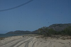
Cape Melville | |
|---|---|
 Beach at Cape Melville | |
| Coordinates: 14°10′12″S 144°31′24″E / 14.17000°S 144.52333°E | |
| Location | Cape York Peninsula, Australia |
| Offshore water bodies | Coral Sea |
Cape Melville is a headland on the eastern coast of the Cape York Peninsula in Australia. To its west lies Princess Charlotte Bay. It is part of the Cape Melville National Park. Cape Melville was named Stoney Cape in 1815 by Lieutenant Charles Jeffreys on the HM Kangaroo but later renamed by him as Cape Melville[1]
Pipon Island is about six km north of the cape and Hales Island about two km east, both part of the Great Barrier Reef Marine Park. King Island lies several kilometres to the north west of the cape. The highest peak on the cape is Abbey Peak, which named in 1901 by Commander Munro. R.N., while aboard HMS Dart.[2]
The cape consists of granite outcrops which formed 250 million years ago.[3]
- ^ "Queensland Government Parks & Forests" .
- ^ "NOMENCLATURE OF QUEENSLAND". The Courier-Mail. Brisbane: National Library of Australia. 30 September 1935. p. 10. Retrieved 5 November 2014.
- ^ "Cape Melville National Park: Nature, culture and history". Department of National Parks, Recreation, Sport and Racing. 10 October 2013. Retrieved 26 October 2013.
