Cape Wolstenholme
| |
|---|---|
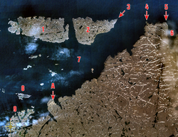
 Location of Cape Wolstenholme (4) and Erik Cove (6). Click on image for full legend. | |
| Coordinates: 62°34′50″N 77°30′35″W / 62.58056°N 77.50972°W | |
| Location | Nunavik, Quebec, Canada |
| Topo map | NTS 35K12 Digges Harbour |
Cape Wolstenholme (/ˈwoʊstənhoʊm/;[3] French: cap Wolstenholme; Inuktitut: Anaulirvik[4]) is a cape and is the extreme northernmost point of the province of Quebec, Canada.[1][2][5][6] Located on the Hudson Strait, about 28 kilometres (17 mi) north-east of Quebec's northernmost settlement of Ivujivik, it is also the northernmost tip of the Ungava Peninsula, which is in turn the northernmost part of the Labrador Peninsula.[2][5]
Its 300 metres (980 ft) high rocky cliffs dominate the surroundings [1] and mark the entrance to the Digges Sound. Here the strong currents from Hudson Bay and the Hudson Strait clash, sometimes even crushing trapped animals between the ice floes.[7]
The cape is the nesting place of one of the world's largest colonies of thick-billed murre.[7]
In the early 2010s, a 1,263 square kilometres (488 sq mi) area alongside the Hudson Strait and including the cape itself was a national park reserve, called Cap-Wolstenholme National Park, with the intention of becoming a full national park of Quebec.[6] The area was later reduced to 777.5 square kilometres (300.2 sq mi), renamed to Iluiliq National Park Reserve, and no longer includes Cape Wolstenholme.[8]
- ^ a b c "Cap Wolstenholme". Banque de noms de lieux du Québec (in French). Commission de toponymie du Québec. 1986-12-18. Retrieved 2018-09-03.
- ^ a b c "Cape Wolstenholme". Geographical Names Data Base. Natural Resources Canada. Retrieved 2018-09-03.
- ^ The Canadian Press (2017), The Canadian Press Stylebook (18th ed.), Toronto: The Canadian Press
- ^ Issenman, Betty Kobayashi (1997). Sinews of Survival: The living legacy of Inuit clothing. UBC Press. pp. 252–254. ISBN 9780774805964. OCLC 231772119. Also ISBN 9780774805995.
- ^ a b "Toporama (on-line map and search)". Atlas of Canada. Natural Resources Canada. Retrieved 2018-09-03.
- ^ a b "Parc national du Cap-Wolstenholme project". Ministère du Développement durable, de l'Environnement et des Parcs Québec. Archived from the original on 2011-06-16. Retrieved 2009-01-03.
- ^ a b "Ivujivik". Nunavik Tourism Association. Archived from the original on 2015-05-22. Retrieved 2009-01-01.
- ^ "Projets de création de parcs nationaux en cours". www.quebec.ca. Gouvernement du Québec. 2023. Retrieved 30 October 2023.
