Capital Region
Höfuðborgarsvæðið (Icelandic) | |
|---|---|
 From upper left: Reykjavík from Perlan, rooftops from Hallgrímskirkja, Reykjavík from Hallgrímskirkja, Fríkirkjan, panorama from Perlan | |
 | |
| Coordinates: 64°11′05″N 21°36′47″W / 64.1846°N 21.6131°W | |
| Country | Iceland |
| Seat | Reykjavík |
| Area | |
• Total | 1,062.2 km2 (410.1 sq mi) |
| Population (2022) | |
• Total | 240,882 |
| • Density | 226.8/km2 (587/sq mi) |
| Time zone | UTC+0:00 (GMT) |

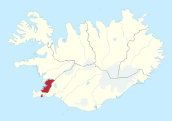
The Capital Region (Icelandic: Höfuðborgarsvæðið, lit. 'capital area'; pronounced [ˈhœːvʏðˌpɔrkarˌsvaiːðɪθ] ) is a region in southwestern Iceland that comprises the national capital Reykjavík and six municipalities around it.[1][2] Each municipality has its own elected council. Municipal governments in the region cooperate extensively in various fields: for example waste policy, shared public transport and a joint fire brigade. The region is home to 64% of Iceland's population.
The region contains Iceland's largest urban area by far, Greater Reykjavík (Icelandic: Stór-Reykjavík), a conurbation that includes parts of six out of seven municipalities of the region (Kjósarhreppur is all rural).
- ^ Association of municipalities in the Capital area English version Archived 2021-10-07 at the Wayback Machine Retrieved on 5. June 2010
- ^ Sigurður Guðmundsson. „Hvernig eru hugtökin dreifbýli og landsbyggð skilgreind hér á landi?“ The Icelandic Web of Science. 18.8.2000. Retrieved on 6. June 2010 (In Icelandic)