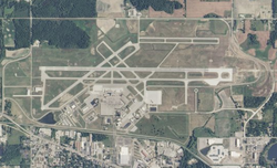
Capital Region International Airport | |||||||||||||||||||
|---|---|---|---|---|---|---|---|---|---|---|---|---|---|---|---|---|---|---|---|
 | |||||||||||||||||||
 | |||||||||||||||||||
| Summary | |||||||||||||||||||
| Airport type | Public | ||||||||||||||||||
| Owner/Operator | Capital Region Airport Authority | ||||||||||||||||||
| Serves | Lansing, Michigan | ||||||||||||||||||
| Location | DeWitt Township, Clinton County, Michigan, USA | ||||||||||||||||||
| Opened | May 1, 1926 | ||||||||||||||||||
| Time zone | Eastern (UTC−5) | ||||||||||||||||||
| • Summer (DST) | (UTC−4) | ||||||||||||||||||
| Elevation AMSL | 861 ft / 262 m | ||||||||||||||||||
| Coordinates | 42°46′43.1″N 84°35′10.3″W / 42.778639°N 84.586194°W | ||||||||||||||||||
| Website | www | ||||||||||||||||||
| Maps | |||||||||||||||||||
 FAA airport diagram | |||||||||||||||||||
 | |||||||||||||||||||
| Runways | |||||||||||||||||||
| |||||||||||||||||||
| Statistics (2021) | |||||||||||||||||||
| |||||||||||||||||||
Capital Region International Airport (IATA: LAN, ICAO: KLAN, FAA LID: LAN), formerly Lansing Capital City Airport, is a public, Class C airport located 3 miles (5 km) northwest of downtown Lansing in a portion of DeWitt Township, Michigan that has been annexed to the City of Lansing via Public Act 425. Small areas of the airport are located in Watertown Township, and Delta Township. It is included in the Federal Aviation Administration (FAA) National Plan of Integrated Airport Systems for 2017–2021, in which it is categorized as a non-hub primary commercial service facility.[5]
The airport is owned and operated by the Capital Region Airport Authority, an eight-member governing board. Three members represent Ingham County and three members represent the City of Lansing. Two ex officio members represent Eaton County and Clinton County.[6] The Airport Authority also oversees nearby Jewett Field (TEW) in Mason.[7]
The Airport Authority reported 180,385 scheduled passengers and 8,085 charter passengers flew to or from the airport in 2021.[1]
- ^ a b Michigan Department of Transportation. Measures of Michigan Air Carrier Demand, Michigan.gov. Retrieved May 17, 2022
- ^ FAA Airport Form 5010 for LAN PDF, effective January 2, 2020.
- ^ Passenger Boarding (Enplanement) and All-Cargo Data for U.S. Airports, Federal Aviation Administration, FAA.gov
- ^ Air Traffic Activity System (ATADS), Federal Aviation Administration. ATADS : Airport Operations : Standard Report, FAA.gov. Retrieved May 17, 2022
- ^ "List of NPIAS Airports" (PDF). FAA.gov. Federal Aviation Administration. October 21, 2016. Retrieved November 23, 2016.
- ^ About CRAA, FlyLansing.com. Retrieved March 16, 2011
- ^ Ingham County. Capital Region International Airport Authority Archived May 13, 2012, at the Wayback Machine, Ingham.org. Retrieved July 6, 2012