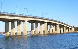
Captain Cook Bridge, Sydney | |
|---|---|
 Captain Cook Bridge, viewed from Sans Souci | |
| Coordinates | 34°00′29″S 151°07′39″E / 34.00794444°S 151.1276083°E |
| Carries | Taren Point / Rocky Point Roads |
| Crosses | Georges River |
| Locale | Southern Sydney, New South Wales, Australia |
| Named for | Captain James Cook |
| Owner | Transport for NSW |
| Preceded by | Tom Uglys Bridge |
| Characteristics | |
| Design | Box girder |
| Material | Precast prestressed concrete |
| Total length | 506 metres (1,660 ft) |
| Width | 27.5 metres (90 ft) |
| No. of spans | 7 |
| No. of lanes |
|
| History | |
| Constructed by | John Holland Group |
| Construction start | 1962 |
| Construction end | 1965 |
| Construction cost | A$3 million |
| Opened | 29 May 1965 |
| Replaces | Punt
|
| Location | |
 | |
| References | |
| [1] | |
The Captain Cook Bridge is a road bridge that carries Taren Point and Rocky Point Roads across the Georges River in southern Sydney, in the state of New South Wales, Australia. The precast prestressed concrete girder bridge crosses near the river mouth as it empties into Botany Bay; and links the St George and Sutherland areas of Sydney. The bridge comprises a dual carriageway with three lanes in each direction of highway grade-separated conditions; and pedestrian and bicycle traffic, via two grade-separated paths. on the eastern and western sides of the bridge.
- ^ "1965 – Captain Cook Bridge". Sydney for everyone. Archived from the original on 21 December 2013. Retrieved 14 June 2014.