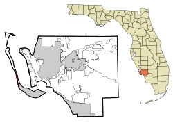
Captiva, Florida | |
|---|---|
 Location in Lee County and the state of Florida | |
| Coordinates: 26°31′5″N 82°11′28″W / 26.51806°N 82.19111°W | |
| Country | United States |
| State | |
| County | Lee |
| Area | |
• Total | 1.64 sq mi (4.26 km2) |
| • Land | 1.18 sq mi (3.06 km2) |
| • Water | 0.46 sq mi (1.20 km2) |
| Elevation | 7 ft (2 m) |
| Population (2020) | |
• Total | 318 |
| • Density | 269.26/sq mi (103.93/km2) |
| Time zone | UTC-5 (Eastern (EST)) |
| • Summer (DST) | UTC-4 (EDT) |
| ZIP code | 33924 |
| Area code | 239 |
| FIPS code | 12-10425[2] |
| GNIS feature ID | 0280017[3] |
| Website | sanibel-captiva |

Captiva is an unincorporated community and census-designated place (CDP) in Lee County, Florida, United States. It is located on Captiva Island. As of the 2020 census, the population was 318,[4] down from 583 at the 2010 census. It is part of the Cape Coral-Fort Myers, Florida Metropolitan Statistical Area.
Located just offshore in the Gulf of Mexico, the island is just north of Sanibel Island. Captiva is accessed by a small bridge that crosses Blind Pass from Sanibel Island. There is a toll to use the causeway that goes from the mainland to Sanibel Island.
Many of Captiva's homes, condominiums, and businesses were destroyed during Hurricane Charley in 2004, but the island recovered shortly thereafter. In September 2022, Hurricane Ian caused significant damage to the causeway and to the infrastructure of the island.[5]
- ^ "2020 U.S. Gazetteer Files". United States Census Bureau. Retrieved October 31, 2021.
- ^ "U.S. Census website". United States Census Bureau. Retrieved January 31, 2008.
- ^ "US Board on Geographic Names". United States Geological Survey. October 25, 2007. Retrieved January 31, 2008.
- ^ "Explore Census Data". data.census.gov. Retrieved September 29, 2022.
- ^ "Ian washed away part of Sanibel Causeway, Sanibel and Captiva cut off from mainland". www.cbsnews.com. September 29, 2022. Retrieved September 29, 2022.