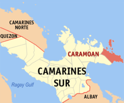
Caramoan | |
|---|---|
| Municipality of Caramoan | |
 Caramoan town proper | |
 Map of Camarines Sur with Caramoan highlighted | |
Location within the Philippines | |
| Coordinates: 13°46′15″N 123°51′47″E / 13.7707°N 123.8631°E | |
| Country | Philippines |
| Region | Bicol Region |
| Province | Camarines Sur |
| District | 4th district |
| Founded | 1945 |
| Barangays | 49 (see Barangays) |
| Government | |
| • Type | Sangguniang Bayan |
| • Mayor | Marilyn Socorro H. Co[1] |
| • Vice Mayor | Dyan S. Ramirez[2] |
| • Representative | Arnulf Bryan B. Fuentebella |
| • SB Members |
|
| • Electorate | 34,357 voters (2022) |
| Area | |
| • Total | 276.00 km2 (106.56 sq mi) |
| Elevation | 14.1 m (46.3 ft) |
| Highest elevation | 1,006 m (3,301 ft) |
| Lowest elevation | 0 m (0 ft) |
| Population (2020 census)[6] | |
| • Total | 51,728 |
| • Density | 190/km2 (490/sq mi) |
| • Households | 11,570 |
| Economy | |
| • Income class | 2nd municipal income class |
| • Poverty incidence | 45.07 |
| • Revenue | ₱ 196.5 million (2020) |
| • Assets | ₱ 373.9 million (2020) |
| • Expenditure | ₱ 148.3 million (2020) |
| • Liabilities | ₱ 43.66 million (2020) |
| Service provider | |
| • Electricity | Camarines Sur 4 Electric Cooperative (CASURECO 4) |
| Time zone | UTC+8 (PST) |
| ZIP code | 4429 |
| PSGC | |
| IDD : area code | +63 (0)54 |
| Native languages | Central Bikol Tagalog |
Caramoan, officially the Municipality of Caramoan (Central Bikol: Banwaan kan Caramoan; Tagalog: Bayan ng Caramoan), is a 2nd class municipality in the province of Camarines Sur, Philippines. According to the 2020 census, it has a population of 51,728 people.[6]
The municipality is located at the tip of the Caramoan Peninsula, a rugged place of land extending into the waters of the Maqueda Channel on the north and east and Lagonoy Gulf on the south. It has been dubbed as the Emerging Paradise of the Pacific due to its white and pink sand beaches known internationally.
- ^ "LGU Directory - Caramoan". Local Government Academy.
- ^ "LGU Directory - Caramoan". Local Government Academy.
- ^ Municipality of Caramoan | (DILG)
- ^ "2015 Census of Population, Report No. 3 – Population, Land Area, and Population Density" (PDF). Philippine Statistics Authority. Quezon City, Philippines. August 2016. ISSN 0117-1453. Archived (PDF) from the original on May 25, 2021. Retrieved July 16, 2021.
{{cite web}}: CS1 maint: year (link) - ^ https://www.philatlas.com/luzon/r05/camarines-sur/caramoan.html.
{{cite web}}: Missing or empty|title=(help) - ^ a b Census of Population (2020). "Region V (Bicol Region)". Total Population by Province, City, Municipality and Barangay. Philippine Statistics Authority. Retrieved 8 July 2021.
- ^ "PSA Releases the 2021 City and Municipal Level Poverty Estimates". Philippine Statistics Authority. 2 April 2024. Retrieved 28 April 2024.


