| Cardamom Mountains | |
|---|---|
| Krâvanh Mountains | |
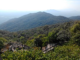
 Vista across the Cardamom Mountains. From Khao Khitchakut National Park (Thailand). | |
| Highest point | |
| Peak | Phnom Aural |
| Elevation | 1,740 m (5,710 ft) |
| Coordinates | 12°00′N 103°15′E / 12.000°N 103.250°E |
| Dimensions | |
| Length | 300 km (190 mi) NW/SE |
| Width | 70 km (43 mi) NE/SW |
| Geography | |
| Countries | Cambodia and Thailand |
| Geology | |
| Rock age | Cambrian[1] |
| Rock type | Metaconglomerate |
The Cardamom Mountains (Khmer: ជួរភ្នំក្រវាញ, Chuŏr Phnum Krâvanh [cuə pʰnum krɑʋaːɲ]; Thai: ทิวเขาบรรทัด, Thio Khao Banthat [tʰīw kʰǎw bān.tʰát]), or the Krâvanh Mountains, is a mountain range in the southwest part of Cambodia and Eastern Thailand. The majority of the range is within Cambodia.
The silhouette of the Cardamom Mountains appears in the provincial seal of Trat Province in Thailand.[2]
- ^ "Cambodia Ecological Zonation" (PDF). Archived from the original (PDF) on 2016-03-04. Retrieved 2012-01-28.
- ^ Seals of The Provinces of Thailand

