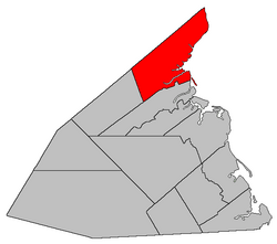
Carleton | |
|---|---|
 Location within Kent County, New Brunswick. | |
| Coordinates: 46°48′18″N 65°03′54″W / 46.805°N 65.065°W | |
| Country | |
| Province | |
| County | Kent County |
| Erected | 1814 |
| Area | |
| • Land | 435.23 km2 (168.04 sq mi) |
| Population (2021)[1] | |
| • Total | 764 |
| • Density | 1.8/km2 (5/sq mi) |
| • Change 2016-2021 | |
| • Dwellings | 413 |
| Time zone | UTC-4 (AST) |
| • Summer (DST) | UTC-3 (ADT) |
Carleton is a geographic parish in Kent County, New Brunswick, Canada.[4]
For governance purposes it is mainly part of the Kent rural district,[5] which is a member of the Kent Regional Service Commission.[6] Small areas on the southern and western boundaries belong to the town of Beaurivage and the village of Nouvelle-Arcadie, respectively.[a]
Prior to the 2023 governance reform, the parish was divided between the local service districts of Pointe-Sapin, east of the national park, and the parish of Carleton, to its west.[8]
- ^ a b "Census Profile". Statistics Canada. 26 October 2022. Retrieved 29 October 2022.
- ^ "Chapter T-3 Territorial Division Act". Government of New Brunswick. Retrieved 26 February 2023.
- ^ "Chapter I-13 Interpretation Act". Government of New Brunswick. Retrieved 26 February 2023.
- ^ The Territorial Division Act[2] divides the province into 152 parishes, the cities of Saint John and Fredericton, and one town of Grand Falls. The Interpretation Act[3] clarifies that parishes include any local government within their borders.
- ^ "Kent Regional Service Commission: RD 6". Government of New Brunswick. Retrieved 26 February 2023.
- ^ "Regions Regulation – Regional Service Delivery Act". Government of New Brunswick. 21 July 2022. Retrieved 26 February 2023.
- ^ "Kent Regional Service Commission: RSC 6". Government of New Brunswick. Retrieved 26 February 2023.
- ^ "Local Service Districts Regulation - Municipalities Act". Government of New Brunswick. 25 June 2021. Retrieved 26 February 2023.
Cite error: There are <ref group=lower-alpha> tags or {{efn}} templates on this page, but the references will not show without a {{reflist|group=lower-alpha}} template or {{notelist}} template (see the help page).