This article needs additional citations for verification. (May 2018) |
Carntyne
| |
|---|---|
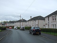
 Typical housing (cottage flats) on Inverleith Street | |
Location within Glasgow | |
| Population | 2,400 (2012 census)[citation needed] |
| OS grid reference | NS631652 |
| • Edinburgh | 44.7 miles |
| • London | 400.0 miles |
| Council area | |
| Lieutenancy area |
|
| Country | Scotland |
| Sovereign state | United Kingdom |
| Post town | GLASGOW |
| Postcode district | G32 |
| Dialling code | 0141 |
| Police | Scotland |
| Fire | Scottish |
| Ambulance | Scottish |
| UK Parliament | |
| Scottish Parliament | |
Carntyne (/ˌkɑːrnˈtaɪn/; Scottish Gaelic: Càrn an Teine) is a suburban district in the Scottish city of Glasgow. It is situated north of the River Clyde, and in the east end of the city. it has formed the core of the East Centre ward under Glasgow City Council, which also includes the neighbouring Riddrie and Cranhill areas.
Carntyne may have derived its name from the Southern Picto-Scot Settlement of Cairn-ton, however Carntyne may be "fire cairn", from Càrn an Teine in the Gaelic, given the abundance of coal in the area. The colliery was closed in 1875 and houses were built in the 1930s, along with an industrial estate.[1]
The district is traditionally split into High and Lower Carntyne (or North and South Carntyne respectively), the division being the A8 Edinburgh Road dual carriageway which bisects the area, and has a largely ageing population. Most amenities are present, although a wider range of shops and leisure options are found nearby in the older areas of Dennistoun to the west, Parkhead to the south-west and Shettleston to the south.
