| Carrauntouhil | |
|---|---|
| Carrauntoohill | |
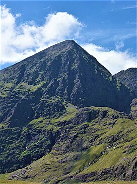
 Carrauntoohil's east face (l), and north-east face (r, in shadow), as seen from the Hag's Glen | |
| Highest point | |
| Elevation | 1,038.6 m (3,407 ft 6 in)[1][2][3] |
| Prominence | 1,038.6 m (3,407 ft 6 in)[1][2] |
| Isolation | 250 miles (400 km) |
| Listing | Country high point, County top (Kerry), P600, Marilyn, Furth, Hewitt, Arderin, Simm, Vandeleur-Lynam |
| Coordinates | 51°59′58″N 9°44′34″W / 51.999445°N 9.742693°W[1] |
| Naming | |
| Native name | Corrán Tuathail (Irish) |
| English translation | Tuathal's sickle |
| Geography | |
| Location | County Kerry, Ireland |
| Parent range | MacGillycuddy's Reeks |
| OSI/OSNI grid | V803844 |
| Topo map | OSI Discovery 78[1] |
| Geology | |
| Rock age | Devonian[1] |
| Mountain type(s) | Purple sandstone & siltstone, (Ballinskelligs Sandstone Formation)[1] |
| Climbing | |
| Easiest route | Devil's Ladder (via Hag's Glen)[4] |
Carrauntoohil,[5] Carrauntoohill or Carrantuohill (/ˌkærənˈtuːəl/ KARR-ən-TOO-əl; Irish: Corrán Tuathail [ˌkɔɾˠaːn̪ˠ ˈt̪ˠuəhəlʲ], meaning "Tuathal's sickle") is the highest mountain in Ireland at 1,038.6 metres (3,407 feet 6 inches). It is on the Iveragh Peninsula in County Kerry, close to the centre of Ireland's highest mountain range, MacGillycuddy's Reeks. Carrauntoohil is composed mainly of sandstone, whose glaciation produced distinctive features on the mountain such as the Eagle's Nest corrie and some deep gullies and sharp arêtes in its east and northeastern faces that are popular with rock and winter climbers.
As Ireland's highest mountain, Carrauntoohil is popular with mountain walkers, who most commonly ascend via the Devil's Ladder route; however, Carrauntoohil is also climbed as part of longer mountain walking routes in the MacGillycuddy's Reeks range, including the 15-kilometre (9+1⁄2 mi) Coomloughra Horseshoe or the 26-kilometre (16 mi) MacGillycuddy's Reeks Ridge Walk of the entire mountain range. Carrauntoohil, and most of the range is held in private ownership and is not part of any Irish national park; however, reasonable access is granted to the public for recreational use.
- ^ a b c d e f "Carrauntoohil". MountainViews Online Database. Retrieved 4 January 2019.
- ^ a b "Ireland's Top 10 Most Spectacular Peaks". Ordnance Survey Ireland. 20 March 2018. Retrieved 12 April 2020.
1. Carrauntoohil Height: 1,038m
- ^ "Carrauntoohil [Corran Tuathail]". HillBaggingUK Database of British and Irish Hills. Retrieved 4 January 2019.
Height=1038.6m / 3407ft
- ^ Cite error: The named reference
jimrwas invoked but never defined (see the help page). - ^ "Carrauntoohil". logainm.ie. Placenames Database of Ireland (Government of Ireland). Retrieved 20 September 2024.
