| Carrieton South Australia | |||||||||||||||
|---|---|---|---|---|---|---|---|---|---|---|---|---|---|---|---|
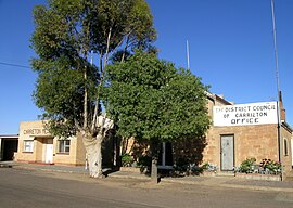
 Carrieton Memorial hall and council office. | |||||||||||||||
| Coordinates | 32°25′34″S 138°31′44″E / 32.426072°S 138.529015°E[1] | ||||||||||||||
| Population | 51 (SAL 2016)[2][3] | ||||||||||||||
| Established | 10 April 1879 (town) 16 December 1999 (locality)[4][5] | ||||||||||||||
| Postcode(s) | 5432[6] | ||||||||||||||
| Elevation | 440 m (1,444 ft)[citation needed] | ||||||||||||||
| Time zone | ACST (UTC+9:30) | ||||||||||||||
| • Summer (DST) | ACST (UTC+10:30) | ||||||||||||||
| Location | 327.8 km (204 mi) N of Adelaide | ||||||||||||||
| LGA(s) | District Council of Orroroo Carrieton[1] | ||||||||||||||
| Region | Yorke and Mid North[1] | ||||||||||||||
| County | Dalhousie[1] | ||||||||||||||
| State electorate(s) | Stuart[7] | ||||||||||||||
| Federal division(s) | Grey[8] | ||||||||||||||
| |||||||||||||||
| |||||||||||||||
| Footnotes | Adjoining localities[1] | ||||||||||||||
Carrieton is a small town situated in the Flinders Ranges of South Australia. It is located between the towns of Orroroo to the south and Cradock to the north.
Originally opened in 1877 as Yanyarrie Whim, (Yanyarrie in the local indigenous dialect is the word for "eagle feathers") with the construction of a post office, the settlement was renamed in 1888 as Carrieton, after the daughter of Governor Jervois, Lucy Caroline.[10]
- ^ a b c d e "Search results for 'Carrieton, LOCB' with the following datasets selected – 'Suburbs and localities', 'Counties', 'Local Government Areas', 'SA Government Regions' and 'Gazetteer'". Location SA Map Viewer. Government of South Australia. Retrieved 28 October 2022.
- ^ Australian Bureau of Statistics (27 June 2017). "Carrieton (suburb and locality)". Australian Census 2016.
- ^ Australian Bureau of Statistics (27 June 2017). "Carrieton (suburb and locality)". Australian Census 2016 QuickStats. Retrieved 28 June 2022.
- ^ "Untitled proclamation under the Crown Lands Consolidation Act re the Town of Carrieton" (PDF). The South Australian Government Gazette. South Australian Government. 10 April 1879. p. 1071. Retrieved 14 February 2018.
- ^ "GEOGRAPHICAL NAMES ACT 1991, Notice to Assign Boundaries and Names to Places" (PDF), The South Australian Government Gazette: 3429, 16 December 1999, retrieved 14 February 2018
- ^ Carrieton Postcode Australia Post
- ^ "Electoral district of Stuart". Electoral Commission SA. Retrieved 12 February 2018.[permanent dead link]
- ^ "Federal electoral division of Grey" (PDF). Australian Electoral Commission. Retrieved 12 February 2018.
- ^ a b c "Climate statistics for HAWKER (nearest station)". Bureau of Meteorology. Retrieved 14 February 2018.
- ^ Manning, G; 1990 Manning's Place Names of South Australia ISBN 05437687505
