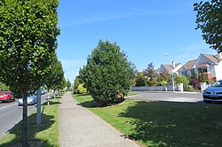
Carrigaline
Carraig Uí Leighin | |
|---|---|
Town | |
 Carrigaline – Heron's Wood | |
| Coordinates: 51°49′00″N 8°23′26″W / 51.8166°N 8.3905°W | |
| Country | Ireland |
| Province | Munster |
| County | Cork |
| Area | |
• Total | 4.6 km2 (1.8 sq mi) |
| Elevation | 17 m (56 ft) |
| Population | |
• Total | 18,239 |
| • Density | 4,000/km2 (10,000/sq mi) |
| Time zone | UTC±0 (WET) |
| • Summer (DST) | UTC+1 (IST) |
| Eircode routing key | P43 |
| Telephone area code | +353(0)21 |
| Irish Grid Reference | W727625 |
| Year | Pop. | ±% |
|---|---|---|
| 1841 | 603 | — |
| 1851 | 780 | +29.4% |
| 1861 | 648 | −16.9% |
| 1871 | 439 | −32.3% |
| 1881 | 576 | +31.2% |
| 1891 | 438 | −24.0% |
| 1901 | 476 | +8.7% |
| 1911 | 518 | +8.8% |
| 1926 | 379 | −26.8% |
| 1936 | 315 | −16.9% |
| 1946 | 357 | +13.3% |
| 1951 | 492 | +37.8% |
| 1956 | 606 | +23.2% |
| 1961 | 688 | +13.5% |
| 1966 | 772 | +12.2% |
| 1971 | 971 | +25.8% |
| 1981 | 4,147 | +327.1% |
| 1986 | 5,893 | +42.1% |
| 1991 | 6,482 | +10.0% |
| 1996 | 7,025 | +8.4% |
| 2002 | 9,345 | +33.0% |
| 2006 | 11,282 | +20.7% |
| 2011 | 14,775 | +31.0% |
| 2016 | 15,770 | +6.7% |
| 2022 | 18,239 | +15.7% |
| [2][3][4][5][6][7][8][9][10] | ||
Carrigaline (Irish: Carraig Uí Leighin, meaning 'rock of Ó Leighin') is a town and civil parish in County Cork, Ireland, situated on the River Owenabue. Located about 12 kilometres (7.5 mi) south of Cork city, and with a population of 18,239 people,[1] it is one of the largest commuter towns in the county.[11] The R611 regional road passes through the town, and it is just off the N28 national primary route to Ringaskiddy. Carrigaline grew rapidly in the late 20th century, from a village of a few hundred people into a thriving commuter town[12][13] although some locals still refer to it as "the village".[14] The town is one of the key gateways to west Cork, especially for those who arrive by ferry from France. Carrigaline is within the Cork South-Central Dáil constituency.
- ^ a b "Carrigaline (Ireland) Census Town". citypopulation.de. Retrieved 1 August 2023.
- ^ "Census 2011 – Population Classified by Area" (PDF). CSO. Archived from the original (PDF) on 12 November 2013. Retrieved 27 February 2014.
- ^ "Historical Overview of Carrigaline". Carrigaline.ie. Archived from the original on 10 January 2016. Retrieved 27 February 2014.
- ^ "Census 2011". CSO. Archived from the original on 9 March 2005. Retrieved 27 February 2014.
- ^ "NISRA – Northern Ireland Statistics and Research Agency (c) 2013". Nisranew.nisra.gov.uk. 27 September 2010. Archived from the original on 17 February 2012. Retrieved 27 February 2014.
- ^ "Carrigaline Village (c.1850)". Carrigaline.ie. Archived from the original on 6 March 2014. Retrieved 27 February 2014.
- ^ Lee, J. J. (1981). "On the accuracy of the Pre-famine Irish censuses". In Goldstrom, J. M.; Clarkson, L. A. (eds.). Irish Population, Economy, and Society: Essays in Honour of the Late K. H. Connell. Oxford, England: Clarendon Press.
- ^ Mokyr, Joel; Ó Gráda, Cormac (November 1984). "New Developments in Irish Population History, 1700–1850". The Economic History Review. Volume. 37 (4): 473–488. doi:10.1111/j.1468-0289.1984.tb00344.x. hdl:10197/1406. Archived from the original on 4 December 2012.
- ^ "Sapmap Area – Settlements – Carrigaline". Census 2016. CSO. 2016. Archived from the original on 13 January 2018. Retrieved 12 January 2018.
- ^ "F1015: Population and Average Age by Sex and List of Towns (number and percentages), 2022". Census 2022. Central Statistics Office. April 2022. Retrieved 29 June 2023.
- ^ "Carrigaline". corkbeo.ie. Retrieved 11 August 2022.
Carrigaline, located about 20 minutes outside the city, is one of the biggest commuter towns in Cork
- ^ "Carrigaline Area Transport Study Executive Summary" (PDF). Corkcoco.ie. 2007. Archived from the original (PDF) on 2 April 2015.
Carrigaline has grown rapidly over the last ten years [1997–2007] and currently [2007] has a population of around 16,000 people
- ^ "Carrigaline calls time on developer-led growth". Irishexaminer.com. Archived from the original on 1 February 2014. Retrieved 27 February 2014.
- ^ "Historical Overview of Carrigaline to Present Day". Carrigaline.ie. Archived from the original on 10 January 2016. Retrieved 27 February 2014.
